
Day 2
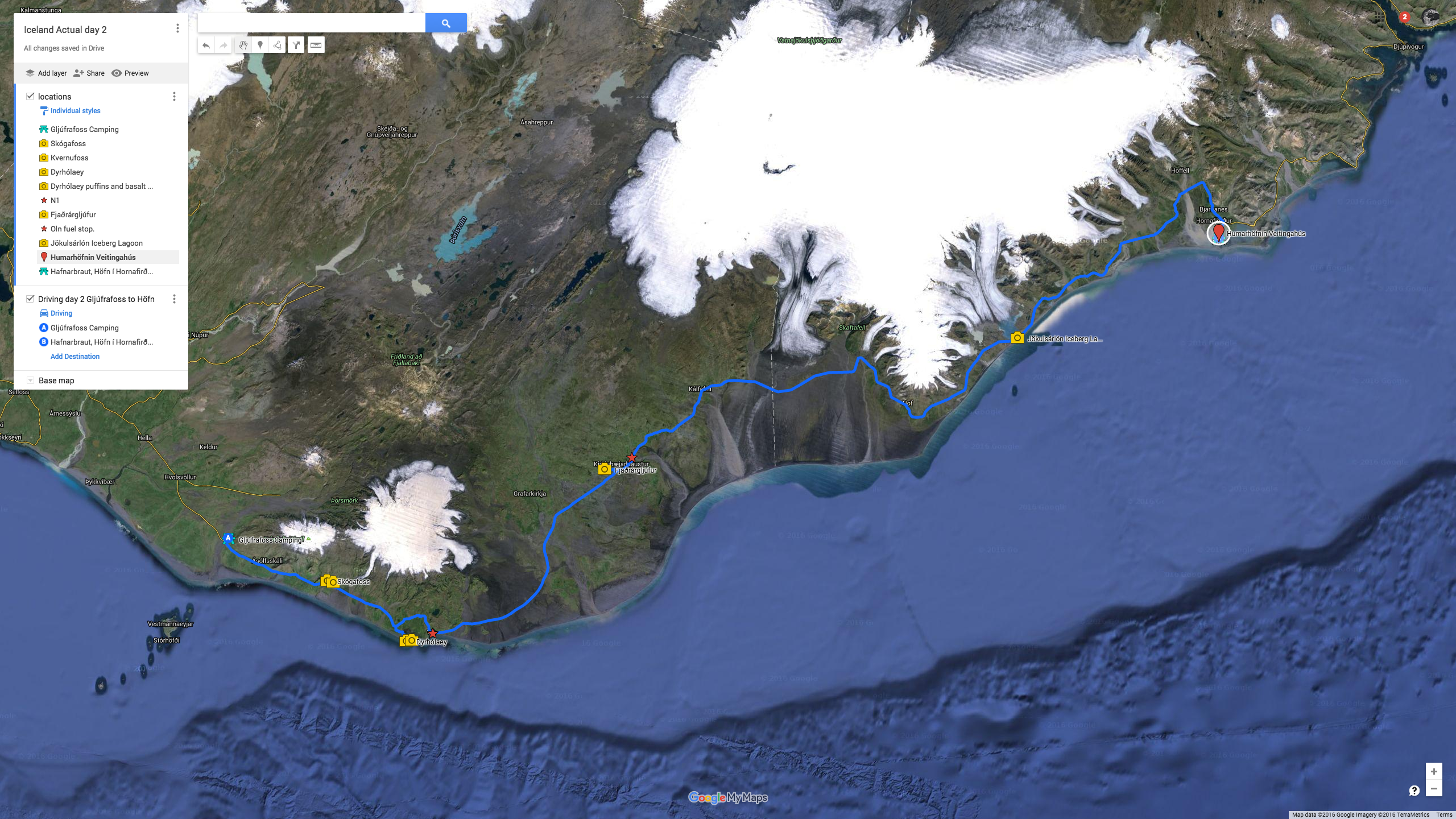
- Day 2 map link
- 337km driven
- Seljalandsfoss 9:00~10:15am
- Skógafoss arrived at 11:15am (after shooting from road)
- Kvernufoss departed at 1:15pm (camera battery #2 done)
- Dyrhólaey 1:45~2:55pm
- Fjaðrárgljúfur (lost valley) 5:30pm
- Jökulsárlón Iceberg Lagoon 7:40pm
- Humarhöfnin Veitingahús (Langoustine Dinner) 9pm
- Fuel in Vik and Skaftárhreppur
- Hafnarbraut campground in Höfn
Day two we slept until 8:30am. We woke up and enjoyed a coffee at the campground which cost 400kr each. Nikki hadn’t seen Seljalandsfoss so we hiked down there together with nothing more than cell phones camera wise which was actually quite nice. It’s a quick 5~10 minute walk down the path with a few smaller waterfalls along the way and a nice babbling brook with butter cups growing in the middle of it. Seljalandsfoss is an amazing experience because you get to walk around a trail that goes behind the waterfall. It’s noisy and it’s wet and it’s truly awesome! It’s lush and green and covered with moss as well.
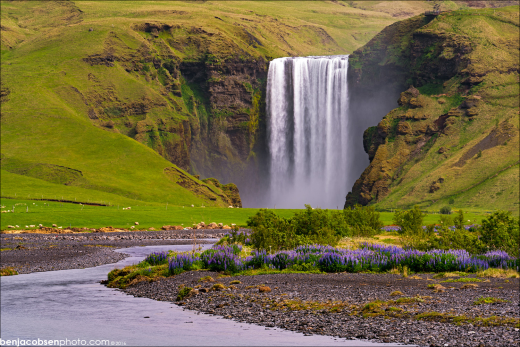 After walking to Seljalandsfoss we headed back to the van and left for Skógafoss. The drive to Skógafoss is beautiful. This is where you start to get into the lupine fields (and they really take over right at Skógafoss) and you’re driving with mountains on the left side of the van and flats out to the ocean on the right. It’s about a 20 minute drive to Skógafoss. Just as Skógafoss came into view I saw the view on the right which is one I’d never seen before. We pulled out into the road to the farm (before the road to the falls) and I grabbed the camera. From there we headed down to the park and hiked into the falls. Skógafoss is an impressive waterfall. Make sure you hike up the trail to at least the midway point where there’s a troll on the side of the mountain (think NH’s old man on the mountain). It’s cute and a great view of the falls on a little dirt ridge line. The hike to the top is all stairs which is nice but it can be full of slower hikers which makes it a bit frustrating at times… I’ve read there’s 25 waterfalls on the hike above Skógafoss but unfortunately we didn’t have enough time to explore any higher (“next time”). After the top we headed down to the bottom of the falls which is an impressive view. The closer you get the less people will be in your shots but the wetter you’ll get. I found taking a few shots and blending the areas without people in them worked best.
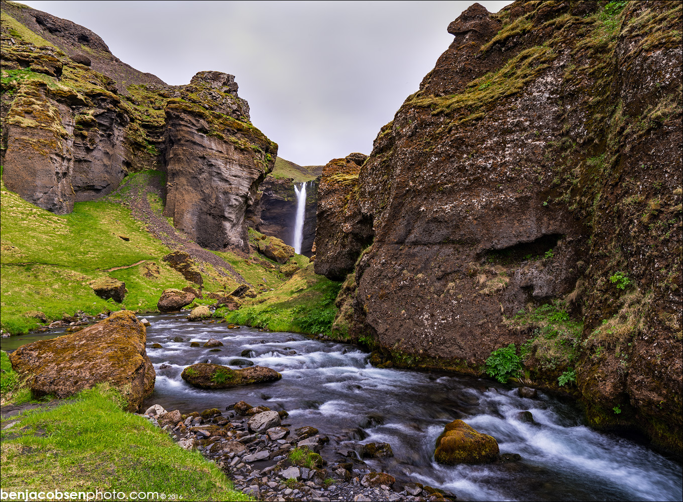
From Skógafoss we headed over to Kvernufoss which is right next door but was practically deserted. A group of three people hiked out as we just got into view of it and another group of ~5 Icelandic kids arrived as we were headed out. We had the place to ourselves the entire time we were there which was amazing. To get to Kvernufoss you park at the far end of the parking lot at the museum. From there hike in behind the last barn/shed to the back corner of the fence where there will be steps to get over the barbed wire. Once you’re over the fence the trail is obvious. It takes 10~15 minutes of a very easy hike to get back to the falls. Once you get over the first ridge you’ll see the top of the falls and you’re treated to an amazing view the whole way in. It feels like a scene out of Jurassic Park! This is another “walk behind” waterfall with a path that leads behind the falls. It’s not as well traveled as Seljalandsfoss but that adds to the fun for me. Expect to get damp or bring a rain coat as the path in has a lot of spray.
We then headed back to the camper and headed off to Dyrhólaey. This drive takes you past the crashed US military airplane on the beach. The gate there is now closed so you must walk in (not sure if you needed a 4×4 before). We weren’t really that interested in the crash to be honest, it kinda feels like it’s American military litter? You can actually just see the plane on the horizon to the right while driving if you look carefully. I do wish we’d stopped and gotten a shot with a long lens… “Next time”!
 The drive in to Dyrhólaey is beautiful. It’s a very low road down on the water with the bluffs rising in front of you. As you approach there’s a dirt road to the right that goes up to the lighthouse or you can continue on to the beach straight ahead. We opted to drive up to the light. A group of cars were parked at the bottom of the hill and hiking but there were no signs to say we couldn’t drive up. It’s a dirt road with a few switch backs and it’s narrow at times (meaning you don’t want to meet another vehicle at those points but plenty of room for one). We made it up with zero issues. The view from the top is amazing as you’re hundreds of feet up on a bluff over an black sand beach that stretches off into the haze. You can also see mountains covered with snow and glaciers in the background behind the lighthouse. The view of the arch is also fun but with unflattering light we don’t have anything other than cell phone images from the top of the bluffs.
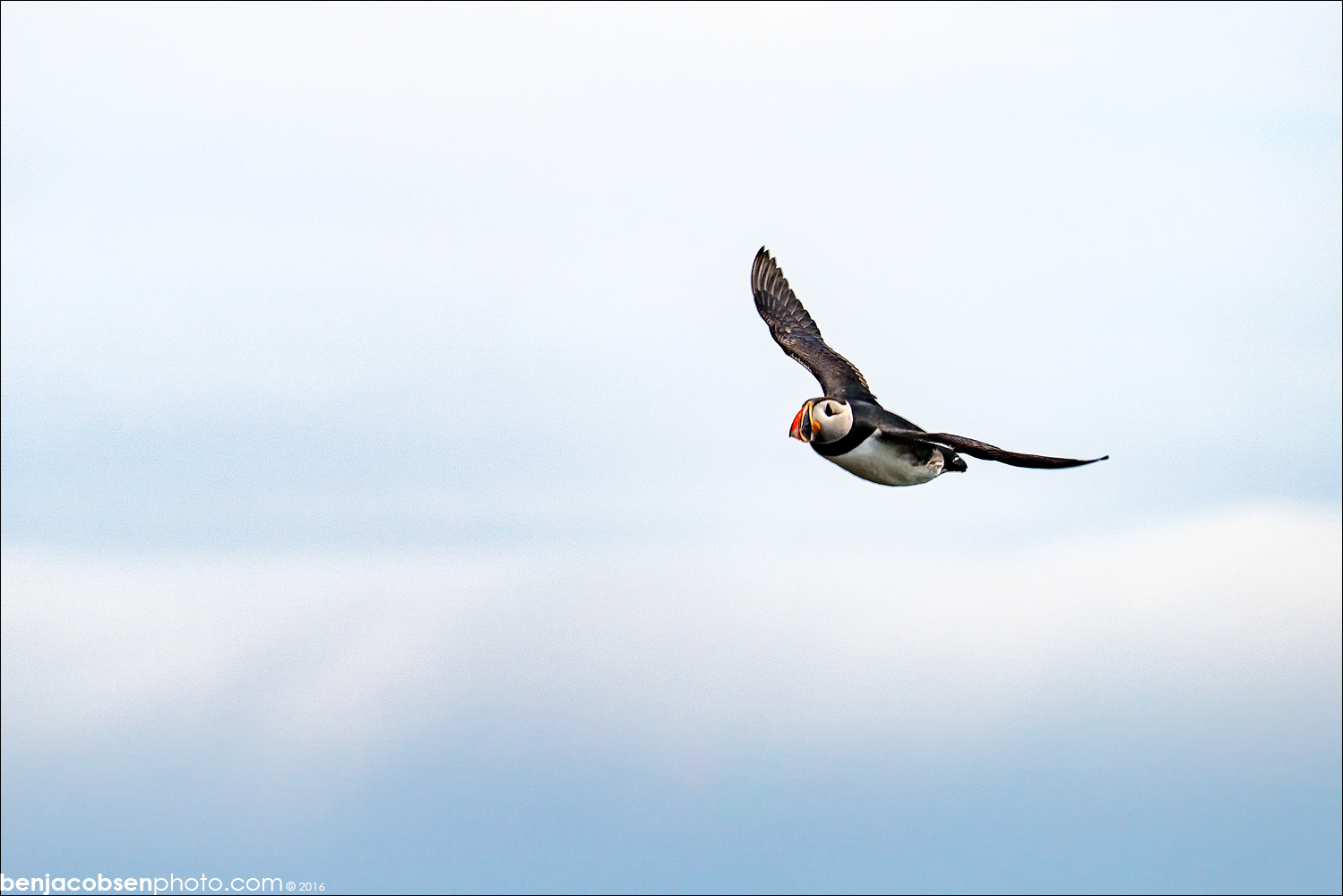
We then headed down to the point with the black sand beach and the birds nests in search of puffins! Walking the path to the left Nikki noticed some black birds in a group out in the water. I put my longest lens on the camera, took a shot and then zoomed all the way in on the screen… PUFFINS! We watched them “commute” between their dens in the cliffside to the NE of the viewing area out to sea and back. They’re small birds and fly very awkwardly so they’re not easy to get pictures of (I have a lot of blank frames!). I was happy to get a few good shots of them. Before heading back to the camper we went to the south end of the parking lot where there’s a warning sign about tides and waves but we ducked the rope and headed to the beach anyway (and stayed out of the water!). This is one of many black sand beaches but it was our first. The sand is warm to the touch as it sits in the sun pretty much all day this time of year. There are also some great basalt columns here worth checking out.
Back to the camper and off to Vik. Vik is a nice small town that has everything you’d need to stock up. There’s a nice campground here, fuel, food, groceries and more. Vik is also home of one of the most photographed churches I know of with their church sitting on a hill over the town that also happens to be covered in lupines. We stopped for fuel and also visited the icewear store/factory (it was next door to the gas station). We ate lunch in the gas station diner (their loaded burger was amazing, ham, bacon, egg, veggies, cheese, LOADED!!!!) and got fuel for the first time on the trip. I’d been told via numerous sites and guide books that I needed a credit card with a pin to get fuel. I called my CC company ahead of time and set everything up and was assured I’d be all set. Of course it didn’t work! Luckily our debit card worked at the pump so we were able to get fuel without going inside (the CC that didn’t work in the pump worked with it’s chip inside all the stores so we could have sorted it out if needed). You pick an amount of fuel in Krona that you want to buy. If you don’t use it all the balance is refunded to your card so guess high (if you don’t get enough you’ll just need more later slowing you down). I didn’t realize this so I bought 3.000kr (15,73l) which was less than half a tank. We weren’t desperate for fuel so we left it at that and headed off towards Höfn.
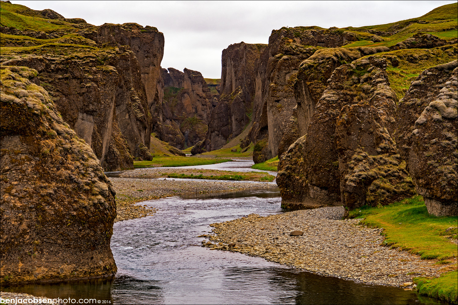 Our next stop was Fjaðrárgljúfur which is a great “lost” canyon. It’s a dirt road for a few KM to get back there but worth the effort. You’ll know you’re there when you see a parking lot with some toilets/WCs on the right side of the road just before a bridge over a small river. We hiked down to the river and across to the other side. This is another place where I wish we’d had more time. There’s a nice hike up the right side of the canyon on an easy grass trail that leads to some spectacular views (according to images I’ve found online since). Going for a quick stop (~30 minutes) at the bottom is worth it, but plan time for the hike if at all possible!
Back in the van we headed east again. We stopped in Skaftárhreppur for fuel and bathrooms again. Nikki got an amazing soft served cone in the N1 with a sea salt topping on it (not sure if it was chocolate or caramel, it was the light brown option) that was amazing. I got more fuel at the Oln stop across the rotary (we had a discount card there and the pumps at N1 were all full). This time I put in 5.000kr (27,19l) which put us pretty close to a full tank.
Leaving Skaftárhreppur the landscape becomes an amazing mix of lupines, moss covered rocks, lava (rock) fields and more. The ground cover changes with very stark lines that must be from different lava flows. One side of a line will be COVERED with one thing (or nothing at all) and the other side of the line will be completely different with no crossover. It makes the drive very interesting which is great because you’re covering a lot of ground here to get out to the iceberg lagoon. The background are also incredible as this is when you start to see glaciers and the ice caps clearly. It was a constant “whoa, look at that!”.
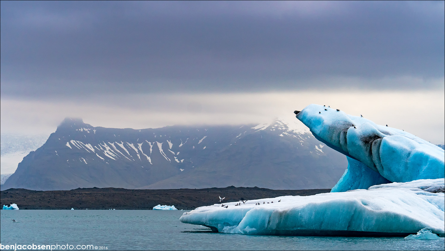 Our next stop was the Jökulsárlón iceberg lagoon. The best access to the lagoon portion is on the north side of the road after crossing the bridge (on your left). Everyone says it’s a “must see” and I now know why. Images do NOT do this place justice. The ice is an amazing color and the scenery is just as good. The backdrop is glaciers and mountains pouring down into this lake that’s full of icebergs. When we were in the parking lot there was a cluster of large icebergs right in front where the lake goes into the stream that leads out to see. I’m guessing the large ice was stuck on the bottom but one of the fun things here was watching and really listening to the ice hit each other as the floating pieces were trying to get around the stuck pieces. It was like listening to car wrecks at times! There are also terns everywhere here. Make sure you stay on the trails and even then it’s not a guarantee they won’t be dive bombing your head! There wasn’t any ice on the beach so we planned to stop again on the way back through the next day.
 After Jökulsárlón we headed off to Höfn for a night of our one dinner out and camping at the Hafnarbraut campground. We drove down into the harbor for dinner. Pakkhús Restaurant was suggested to us by a friend but when we arrived at 9pm we were told their wait already exceeded their 10pm closing time so they weren’t accepting anyone else. We headed across the street to Humarhofnin which is also very well reviewed and known for their langoustine (Icelandic Lobster). Nikki and I both enjoyed an expensive (which we knew going in) langoustine dinner which was delicious! After dinner we headed to the campsite and met Linda (follow her on instagram) who runs the show at the campground. She was VERY friendly and helpful with suggestions on where to go next! We both showered and headed off to bed for the night parked down by the harbor in a wonderful quiet corner of the camp site. Camping here was 1100kr per adult and showers were only 100kr for 2 minutes.
I hate to say this but since returning from Iceland and mentioning our trip it’s been brought up that there’s a Justin Beiber video that was shot in Iceland. I’ve since found it and EVERYTHING in his video was part of our day 2 portion of the trip. We skipped the plane but otherwise it’s shot where we were for our day two. Here’s the video if you’re curious:


Leave a Reply